Home Information Pictures Maps Google Map Earthquakes Be prepared ShakeOut! Feel it? Big One
Tectonics Volcanoes Tsunamis California geology History Myths Organizations Links About Research
![]()
The San Andreas fault's nick name is "SAF".
Visit the San Andreas Fault
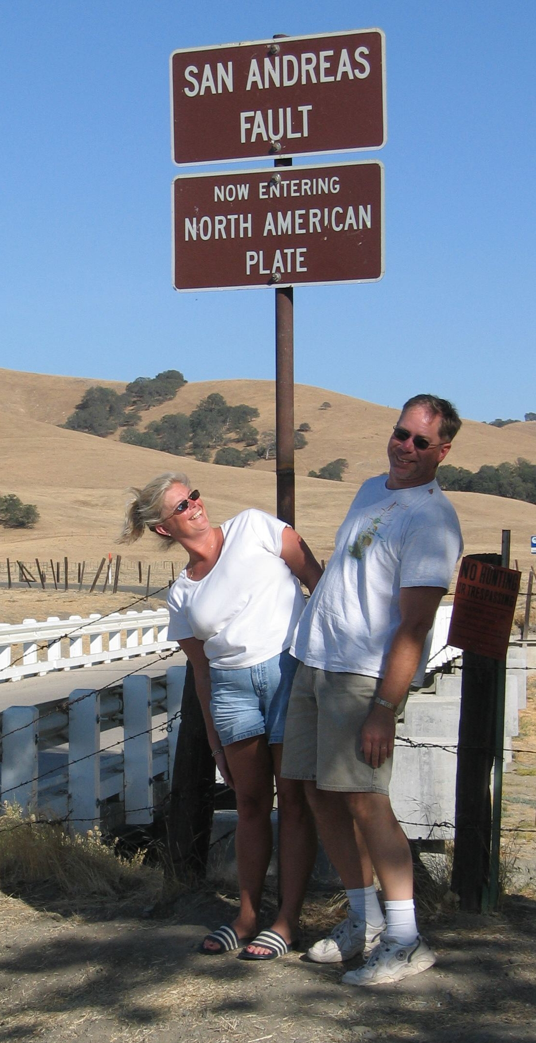

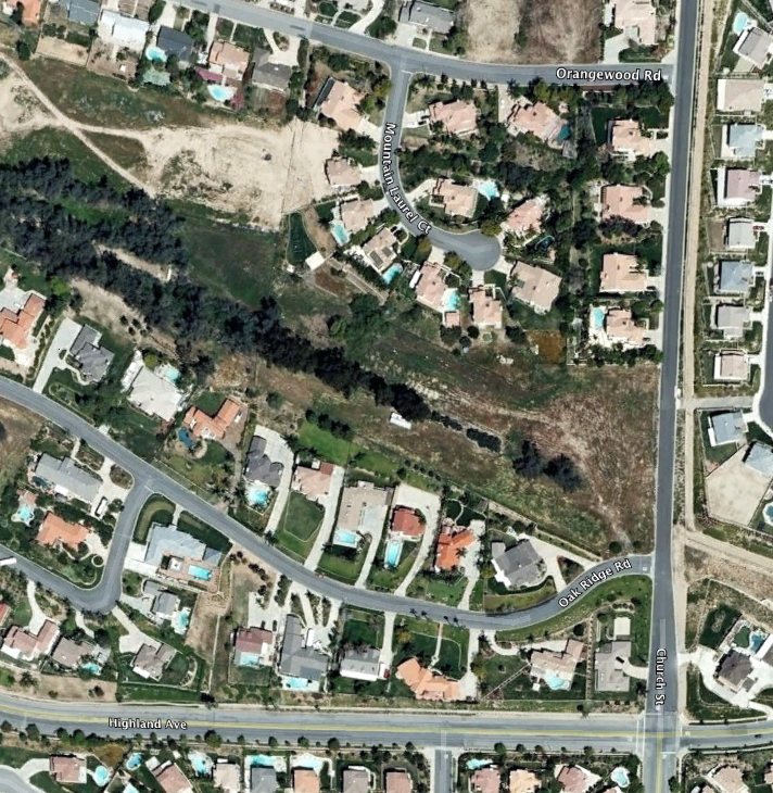
Parkfield bridge, Palmdale road cut, Wallace Creek and the SAF in Highland, CA.
|
|
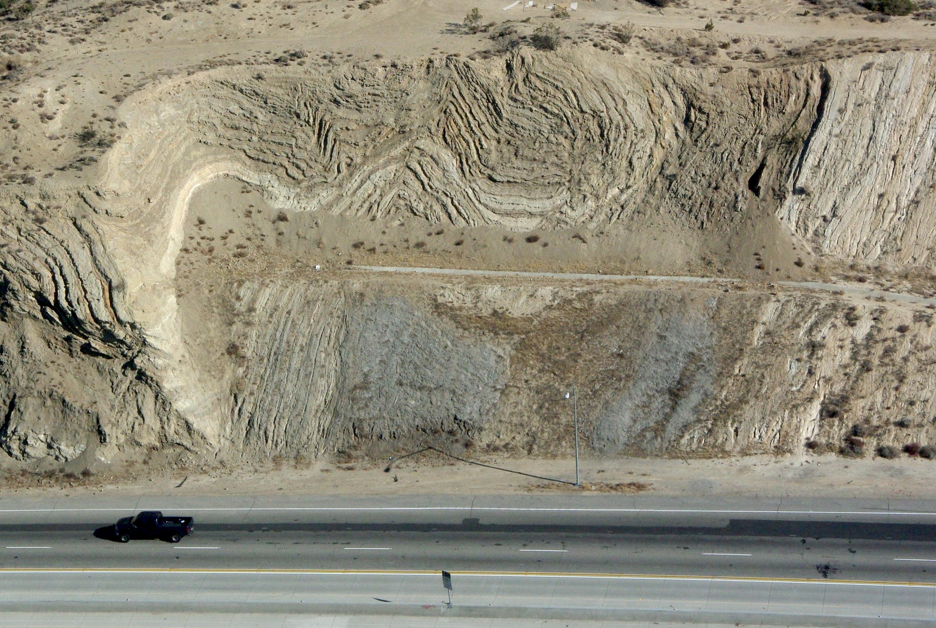
Finding the fault is relatively easy. Seeing the fault is another matter. The SAF has not had a major ground-rupturing earthquake since 1906. Virtually all traces of the "giant crack in the ground" that so many people image the SAF to be have been erased. Erosion fills and covers the fault, plows and bulldozers reshape the surface, roads and neighborhoods are built on the fault. The actual surface trace of the fault is subtle. What one has to look for are the land forms that the plate motion has created. These include but are not limited to offset streams and channels, pressure ridges, scarps, different rocks on either side of the fault, fault gouge, sags and sag ponds. |
 Visiting the fault is easy. All it takes is a decent car. No 4WD is necessary unless you want to get to a few difficult places, and most of these are just a short hike from a public road. In some places like the Morongo Indian Reservation or the San Bernardino Mountains, you are not permitted entry or there simply are no public roads (but you can back pack in or day hike). Otherwise, access is a breeze. Many sections of the fault are in National Parks, National Forests or on BLM land. With hundreds of miles of mostly quiet, scenic roads, you'll see dramatic land forms, horribly twisted rock, and lots of wildlife and flowers.
 Finding the Fault
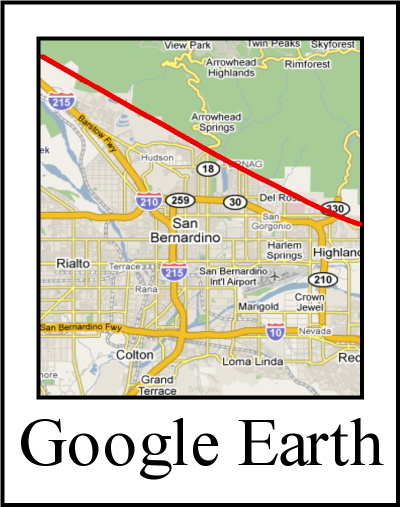
Start here to plan your self-guided trip anywhere along the SAF.Google Map showing the main trace of the SAF.
This is the book you'll need. 1100 miles of annotated road logs, hundreds of GPS locations, full color.
Field Guide to the San Andreas Fault
Web-available, regional self-guided field trips
Northern California and the San Francisco Bay Area"Amateur Geologist" field trips
Many geology field trips
SAF field trips
Hayward fault through UC Berkeley
Calaveras fault through Hollister
Geology of the Golden Gate Headlands (downloads PDF to your computer)
Geology of the Marin Headlands and the Half Moon Bay Coast (downloads PDF to your computer)
Central California and the Carrizo Plain
Wallace Creek area
Southern California
Cities and communities in the SAF zone
Indio, Desert Hot Springs, Highland, Amber Hills, San Bernardino, Devore, Wrightwood,
Mile High, Valyermo, Little Rock, Pearblossom, Palmdale, Leona Valley, Munz Lakes,
Elizabeth Lake, Lake Hughes, Gorman, Frazier Park, Lake of the Woods, Cuddy Valley,
Pine Mountain Club, Cholame, Parkfield, San Juan Batista, Aromas, Lexington Hills,
Los Trancos Woods, Portola Valley, Westridge, Woodside, Emerald Lake Hills,
Highlands-Baywood Park, Hillsboro, Pacifica, Daly City, Mussel Rock, Stonestown,
Broadmore, Stinson Beach, Bolinas, Olema, Point Reyes Station, Dillon Beach,
Bodega Bay, Fort Ross, Manchester State Beach, (Mendocino), (Fort Bragg),
(Shelter Cove), Cape Mendocino Area.
Parks on or near the SAF
Imperial County
Sonny Bono Salton Sea National Wildlife Refuge
Wister Unit, Imperial Wildlife Area
Salton Sea State Recreation Area
Riverside County
Mecca Hills County Park
Thousand Palms Oasis Preserve
Indio Hills Palms
San Bernardino County
Blue Cut
San Bernardino National Forest
Yucaipa Regional Park
Big Morongo Canyon Preserve
Los Angeles County
Devil's Punchbowl Natural Area
Barrel Springs Trail
Pelona Vista Park
Everett Martin Park
Kern County County
Frazier Park Community Center
Los Padres National Forest
San Luis Obispo County
Carrizo Plain National Monument
Monterey County
San Benito County
San Juan Bautista State Historic Park
Hollister Hills State Vehicular Recreation Area
Pinnacles National Park
Santa Cruz County
Aldridge Lane Park
Santa Clara County
Mt Madonna County Park
Sanborn County Park
Stevens Creek and Upper Stevens Creek County Parks
San Mateo County
Mussel Rock Park
Crystal Springs (Sawyer Camp Trail)
Los Trancos Open Space Preserve
Marin County
Tomales Bay State Park
Marconi Conference Center State Historic Park
Point Reyes National Seashore
Golden Gate National Recreation Area
Agate Beach
Bolinas Park
Sonoma County
Sonoma Coast State Park
Fort Ross State Historic Park
Salt Point State Park
Kruse Rhododendron State Natural Reserve
Manchester State Park
Mendocino County
Humbolt County
Published field guides not on the web
Alt, D. and Hyndman, D. W., Roadside Geology of Northern and Central California, Mountain Press Publishing Co., Missoula, Montana, (2000)
Baldwin, J., M. Payne and L. Lewis, Field Trip along the San Andreas Fault Zone From Whitewater to Bombay Beach, Salton Trough, California, in South Coast Geological Society Annual Field Trip Guide Book (J. Baldwin, L. Lewis, M. Payne and G. Roquemore, eds), No. 25, 1-34 (1997)
Ehlig, P. L. & J. C. Crowell, Field Trip Guide to the San Andreas Fault in Southern California, in San Andreas Fault in Southern California, A Guide to the San Andreas Fault from Mexico to Carrizo Plain, Calif. Div. Of Mines and Geology, Special Report 118 (J. C. Crowell, ed.), 253 - 272, (1975)
Galloway, A. J., Geology of the Point Reyes Peninsula, Marin County, California, CDM Bulletin 202 (1977)
Hyndman, Donald W. and David D. Alt.† Roadside Geology of Northern and Central California. Mountain Press Publishing Company; Missoula, MT, 2000.†
Konigsmark, Ted. Geologic Trips:† San Francisco and the Bay Area .† GeoPress, Gualala, CA, 1998.
Schiffman, P and D.L. Wagner, Field Guide to the Geology and Metamorphism of the Franciscan Complex and Western Metamorphic Belt of Northern California (for the International Symposium "The Transition from Basalt to Metabasalt: Environments, Processes, and Petrogenesis"), 1992 CGS SP 114
Sharp, R. P. and A. F. Glazner, Geology Underfoot in Southern California, Mountain Press Publishing Co., Missoula, Montana, (1993)
Sieh, K. E. and J. C. Matti, The San Andreas Fault System Between Palm Springs and Palmdale, Southern California: Field-Trip Guidebook, in Earthquake Geology San Andreas Fault System Palm Springs to Palmdale, Guidebook and Reprint Volume (K. E. Sieh, and J. C. Matti, eds), Association of Engineering Geologists, Southern California Section, 1 - 12, (1992)
Sloan, D. and D.L. Wagner (eds) Geologic Excursions in Northern California: San Francisco to the Sierra Nevada (For Joint Meeting of Geological Society of America and Seismological Society of America), 1991, CGS SP 109
Stoffer P. W. and L. C. Gordon (eds), Geology and Natural History of the San Francisco Bay Area:†A Field-Trip Guidebook - US Geological Survey Bulletin 2188, 2001.
Sylvester, A.G., and Crowell, J.C., leaders, The San Andreas Transform Belt, International Geological Congress Field Trip, 28th, guidebook T309, p. T309:49-T309:51.
Wagner, D. L. and S. A. Graham, Geologic Field Trips in Northern California (For the Cordilleran Section of the Geological Society of America), 1999 CGS SP 119
Wagner, David L. and Stephan A. Graham, (eds.) Geologic Field Trips in Northern California: Centennial Meeting of the Cordilleran Section of the Geological Society of America.
Prentice, Carol S. 2006 1906 San Francisco earthquake centennial field guides: field trips associated with the 100th anniversary conference, 18-23 April 2006, San Francisco, California. Field Guide (Geological Society of America), Volume 7
Please help us make this site better. Email us suggestions, pictures, links, etc. here.